
Dec
7
7:30 PM19:30
History of Earthquakes in the Western Solomon Islands
Fred Taylor, University of Texas Institute for Geophysics
Calendar
Fred Taylor, University of Texas Institute for Geophysics
Abstract
House Bill 1458 sponsored by Representative Lena Guerrero in the House and Senator Santiesteban in the Senate, was passed by the 70th Legislature in 1989, set out the state’s groundwater protection policy, and created the Texas Groundwater Protection Committee (TGPC) in Chapter 26 of the Texas Water Code. Since that time, the TGPC has implemented the state’s policy of non-degradation of the state’s groundwater resources by coordinating groundwater protection activities of the agencies represented on the Committee, developing and updating a comprehensive groundwater protection strategy for the state, studying and recommending to the legislature groundwater protection programs for areas in which groundwater is not protected by current regulation, and publishing a joint groundwater monitoring and contamination report. Abandoned water wells have been a major concern to the TGPC for many years, as they are a threat to groundwater and public safety. Abandoned wells provide a direct channel for pollution of the aquifer below, through the direct introduction of contaminants with no opportunity for natural filtration by soils or geologic materials. The TGPC continues to advocate for enhanced groundwater protection through abandoned well plugging and educational outreach.
Biography
Cary began his career with the Texas Water Commission’s Water Quality Division in 1989, after working several years in the private sector for an engineering firm specializing in land development and municipal projects. In 1991, he was tasked with building a team to conduct Groundwater Impact Evaluations for Wastewater Permits.
When the agency became the TNRCC, Cary and his team were reorganized into the Groundwater Assessment Section. There, he served in various capacities, focusing primarily on statewide groundwater monitoring and Edwards Aquifer issues. In 2007, Cary assumed the role of the Executive Director’s personal representative to the interagency Texas Groundwater Protection Committee, where he serves as the designated chairman.
Cary was recently appointed Manager of the newly created Permit Support, Compliance and Groundwater Section in TCEQ’s Water Availability Division where he oversees groundwater protection and surface water rights compliance programs. He is a member of the federal Advisory Committee on Water Information’s (ACWI’s) Subcommittee on Ground Water (SOGW) that has developed a national groundwater monitoring program. Cary has also been actively involved with the national Ground Water Protection Council, serving on their Water Quality Division Oversight Group and chairing their Aquifer Storage and Recovery Task Force.
Locally, he represented the TCEQ during the development and implementation of the Edwards Aquifer Recovery Implementation Program (EARIP), and is serving on the Williamson County Conservation Foundation’s Adaptive Management Committee and the Georgetown Salamander Adaptive Management Working Group.
For Cary, serving Texas and Texans is an honor. He is a sixth generation native Texan from Houston, and holds a Bachelor of Science degree in Geoscience from University of Texas at Austin. He is a licensed Professional Geoscientist in the state. When not at TCEQ, Cary splits his time between his family’s newest generation of Texans, working in the rapidly growing Texas wine industry, and doing preservation work on the battleship U.S.S. Texas.
Robert L. Folk and Earle F. McBride, UT Austin
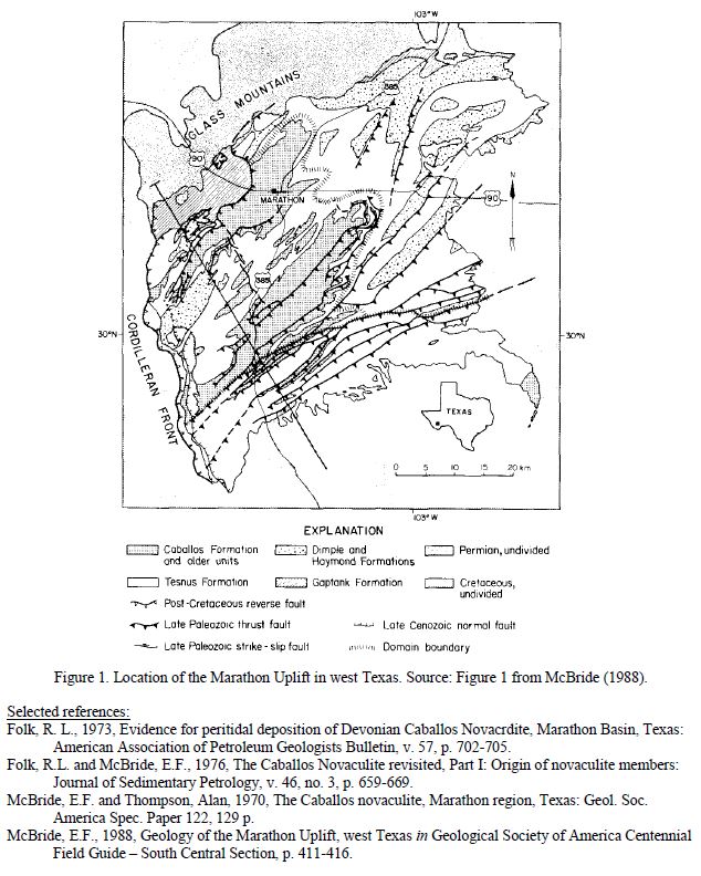
Drs. Folk and McBride have a long-standing disagreement on the origin of novaculite units within the Silurian-Devonian-age Caballos Formation, which crops out in the Marathon region of Trans-Pecos Texas (Figure 1). The Marathon uplift is a topographic basin, but a structurally high remnant of southwest-northeast trending Ouachita mountain chain, which is otherwise buried by sediments throughout Texas. Novaculite is an uncommon rock type thought by some to be metamorphosed bedded chert. Folk and McBride (1976) describe the two Caballos novacultite members as “white, pelletal, spiculitic chert”. In the early 1970s Folk and McBride independently came up with contrasting descriptions for the origin of the novaculites. McBride and Thompson (1970) proposed deposition in a deep marine environment; Folk (1973) interpreted the depositional environment as “shallow marine with occasional subaerial exposure”. They chose to revisit field exposures of the rocks together in 1972, and subsequently published a collaborative article on their differing interpretations (Folk and McBride, 1976). In October they will continue their good spirited debate on the origins of the Caballos Novaculite for the Austin Geological Society.
Biographies
Dr. Robert L. Folk was born 30 Sept. 1925 in Shaker Heights in Cleveland, Ohio. He obtained all three degrees from the Pennsylvania State College, Ph.D. 1952. From 1953-1988 he taught sedimentary geology at The University of Texas at Austin. He has won two medals for his work in sedimentary petrology, and two national teaching awards. In 1974, Dr. Folk published Petrology of Sedimentary Rocks, a reference guide used in teaching throughout the world. The book was reprinted in 1980, and in 2002 he donated it to the Walter Geology Library at UT Austin to be scanned and made available via the internet. Dr. Folk has had a life-long passion for all things Italian, and conducted much research in Viterbo and Acireale, Italy. In 1980 he first became interested in the role of bacteria in forming materials. After retiring from teaching in 1988, Dr. Folk became intrigued by the influence of nannobacteria on formation of minerals and weathering of rocks; in 1990 he discovered, along with Drs. Brenda Kirkland, F. Leo Lynch, and Amanda Lawrence the first mineralized nannobacteria. To read more about this passion of his, visit: http://www.jsg.utexas.edu/researcher/robert_folk/.
Dr. Earle F. McBride became an instructor at The University of Texas at Austin in 1959, and received a Ph.D. from Johns Hopkins University in 1960. Dr. McBride, also an author of numerous scientific articles, guidebooks, and references on deep water sedimentation (especially flysch deposits), continued teaching sedimentary geology at UT Austin Department of Geological Sciences until his retirement in 2005. In the 1970s and 1980s, he had visiting professorships at the University of Kansas (distinguished), the University of Perugia, Italy (sponsored by NATO), and consulted for a Mexican commission for coal exploration. Dr. McBride served as geology department chair at UT Austin from 1980-1984. His chief interests remain sandstone diagenesis, physical and chemical properties that alter sandstone, and the fate of sandstone pores, which he has applied in geological consulting work with over a dozen oil companies throughout his career. In 2011, Dr. McBride along with M. Dane Picard discovered relict evidence of the WWII D-Day battles on Omaha Beach in France in the form of small spherical beads of iron and glass, which are fused remnants of shrapnel and quartz sand. For more information on the Omaha Beach discoveries, see: http://coastalcare.org/2012/06/d-days-legacy-sands-omaha-beach/.
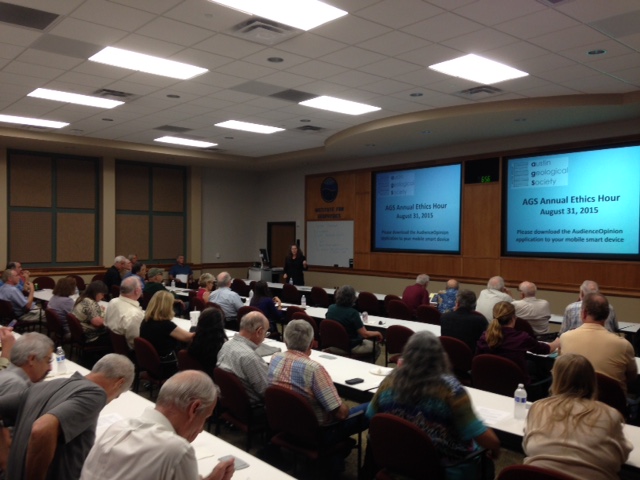
The always popular AGS fall kick-off One-hour Ethics Training this year will use a real-time audience participation element to let you learn about the relationship between your own interpretations of an ethical response and the interpretations of your peer AGS members. Please come prepared to participate by bringing your “smart phone” or wireless internet-ready device (e.g. iPad). If you have two devices, please consider bringing one to lend a fellow AGS member who is not so equipped. Paper-and-pencil participation will also be supported, as well as an invitation for members of the audience to offer short verbal responses. If you want to be super-prepared, please use this link to download the app we will be using: https://www.audienceopinion.com/devices .
Dr. Susan Hovorka, BEG (content organizer) and Dallas Dunlap, BEG (technology organizer) will lead this session, but the major speaker will be you.
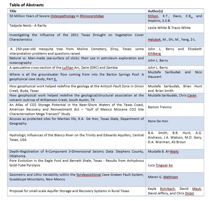
Below is the list of posters presented at the annual AGS poster session.
The karstic Edwards aquifer supplies water to a rapidly increasing population in Central Texas. The three segments of the aquifer—the Barton Springs segment, the San Antonio segment, and the Northern segment—have received varying amounts of study. The presenters will discuss what is known about flowpaths, hydrogeologic reactivity, aqueous geochemistry, and contaminant concentrations in the three segments, with a focus on the data gaps that remain.

Biographies
Barbara Mahler (right) is a Research Hydrologist at the USGS Texas Water Science Center in Austin. Her research has focused on using geochemistry to better understand karst hydrosystems. Most of her research has been on the Edwards aquifer in Central Texas and karst aquifers in northeastern and southern France.
MaryLynn Musgrove (left) is a Research Physical Scientist at the USGS Texas Water Science Center in Austin. Her research has focused on using geochemistry to better understand groundwater systems with a focus on karst aquifers, including the Edwards aquifer.
Wolfberry play combines favorable geology with innovative completion practices to form one of the largest unconventional oil plays in the United States. Wolfberry wells produced almost 55 million barrels of oil in 2011, and potential exists for that figure to double in a few years. Abundant organic carbon, brittle calcareous mudrock, and thin permeable beds form the geologic basis for the play. The Wolfberry concept grew out of preexisting plays in low-permeability sandstones (Spraberry Formation) and detrital carbonates (Wolfcamp interval) and developed in the early 2000’s through the application of modern hydraulic-fracture stimulation technology and refinement of geologic understanding of the reservoir-source-rock system. This presentation covers Wolfberry geology at regional and local scales and is intended to provide a context and reference for exploration and development.
Lower Permian (Wolfcampian and Leonardian Series) stratigraphy in the Midland Basin records deposition in an intracratonic, deep-water basin surrounded by shallow-water carbonate platforms. On the basin floor, siliciclastic, turbidite depositional systems alternate with calcareous, hemipelagic depositional systems in horizontal, laterally persistent layers. Turbidite sandstones form important reservoirs in basin-floor settings. Along the platform margins, slope depositional systems comprise carbonate-dominated clinoforms. Near-slope (periplatform) detrital carbonates (primarily debris flows and turbidites) form important Wolfberry reservoirs. By flooding or exposing the wide platforms, sea-level fluctuation controlled sediment input into the basin. During sea-level lowstands, platforms were exposed, and siliciclastic sediment was transported directly into the basin. During sea-level highstands, flooded platforms became carbonate factories, and sediment input to the basin comprised platform-derived carbonate and hemipelagic (windblown) silt and clay. The hemipelagic depositional system was active throughout the sea-level cycle, and organic matter and siliciclastic silt are abundant in all basinal intervals.
We used wireline logs to correlate and map stratigraphic intervals and drill cores to characterize lithofacies and calibrate wireline logs for lithofacies identification and mapping beyond cored wells. On the basis of lithofacies composition, rock-body geometries, and bedding architecture, we interpreted depositional facies and elements within the sequence stratigraphic and paleogeographic framework.
Siliciclastic intervals include the lower Wolfcamp interval, the Dean Formation, and the lower and upper intervals of the Spraberry Formation. These inferred lowstand intervals comprise submarine fans that extend over 150 mi (241 km) north-south and cover the basin floor. Spraberry and Dean sandstone turbidites are composed of very fine grained sand and coarse silt derived from source areas in the north. Permeable turbidite channel sandstones thin southward, grading into low-permeability turbidite lobes and sheets having widespread lateral continuity. The lower Wolfcamp interval forms a west- and north-thinning wedge of siliciclastics derived from tectonic source areas to the east and south.
Calcareous intervals include the upper Wolfcamp interval, lower and middle Leonard intervals, and middle interval of the Spraberry Formation. These inferred highstand intervals, which form equally widespread layers on the basin floor, are composed of hemipelagic deposits (mudrocks and calcareous mudrocks) and detrital carbonate mass flow deposits. Basinal calcareous intervals are typically thicker, coarser grained, and more permeable near the platforms that supplied the carbonate detritus. In basin-center areas, calcareous intervals are mudrock dominated but include numerous thin, permeable interbeds.
Wolfberry basinal deposits are oil rich, but most lithofacies are relatively impermeable. Mudrocks are organic rich, thermally mature, and oil prone. Sandstones and carbonates are mostly thin and of poor reservoir quality. The Wolfberry reservoir-source-rock system, however, is more than 2,000 ft (610 m) thick, and by means of massive, multistage, hydraulic-fracture stimulation treatments, large volumes of marginal reservoirs are accessed and produced.

Biography
Dr. Herbert Scott Hamlin has been a Research Scientist Associate at the Bureau of Economic Geology since September 2007. He obtained his B.A in anthropology and M.A. and Ph.D. in geology from the University of Texas at Austin. His fields of expertise are sedimentary geology, stratigraphy, basin analysis, hydrocarbon reservoir characterization, hydrocarbon play analysis, hydrogeology, groundwater flow modeling, GIS, geostatistics, and relational databases.
Prior to his current work at the BEG he was a Hydrologist at the Texas Water Development Board from 2004 to 2007 where he was involved in groundwater availability modeling. From 1983 to 2001 Dr. Hamlin was a research associate at the BEG, during which time some of his work included investigating petroleum resources in Texas, Wyoming, Australia, and Venezuela and modeling groundwater flow and contaminant transport around salt domes.
In central Texas, the Balcones Fault Zone separates the Gulf Coastal Plain from the elevated Hill Country/Llano Uplift/Edwards Plateau province to the west and north. The youngest geologic formations common to both provinces are the thick, widespread Edwards Limestone (Albian), and the thin overlying Georgetown, Del Rio, Buda, and Boquillas (Cenomanian) formations. Younger Cretaceous and Tertiary formations beneath the Gulf coastal plain have no known counterparts west and north of the Balcones Fault Zone.
The Late Cretaceous and Tertiary geologic history of the Central Texas Platform may be summarized:
a) The vast Edwards carbonate bank was mantled beneath a covering veneer of thin (<100 feet) Cenomanian formations (Del Rio, Buda, and Boquillas [=Eagle Ford]).
b) The Central Texas Platform was covered by 500 to 1,500 feet of open marine Austin Chalk (Santonian), Taylor Clay and Navarro Marl (Campanian and Maastrichtian), and Paleocene Midway Clay.
c) Throughout the Eocene (36 my), the exposed, low-lying bank (adjacent to coastal-plain and fluvial deltaic depositional tracts) began to be gently uplifted.
d) Beginning in Oligocene time, accelerating gulfward tilting and uplift increased exposure and erosion of the buried Central Texas Platform, until Georgetown and Edwards rocks began to be exposed and eroded, their detritus deposited in alluvial aprons on the adjacent coastal plain. Balcones faulting during late Oligocene and Miocene marked the culmination of uplift along the west and north side of the Balcones Fault Zone.
e) Continued regional uplift during late Miocene and Pliocene elevated the western margins of the exposed Edwards carbonate bank, tilting the Plateau surface gently toward the southeast. Headward erosion from east and south established the basic pattern of headwater springs from the Plateau Aquifer sourcing outward-flowing streams that charged the newly created and expanding Edwards Underground Aquifer, where they crossed the faulted rocks of the Balcones Fault Zone. Approximately 5,000 cubic miles of rock was removed by erosion and solution from the Edwards Plateau, Llano Uplift, Hill Country and uppermost Gulf coastal plain as the result of Tertiary uplift and Balcones faulting.


Biography
Dr. Pete Rose (Ph. D., Geology, University of Texas, Austin) has been a professional geologist for 55 years, specializing in Petroleum Geology, E&P Risk Analysis, and Mineral Economics. Before going on his own in 1980 as an independent prospector and consultant, he worked for Shell Oil Company, the United States Geological Survey, and Energy Reserves Group, Inc, a small-cap Independent.
After 10 years as an internationally-recognized authority on economic risking of exploration drilling ventures, he founded Rose & Associates, LLP, in 1998. Pete retired in 2005; the firm continues as the global standard among consulting companies in that field, providing instruction, software and consulting services on an international scale.
Pete wrote the definitive geological monograph on the Edwards Limestone of Texas (Rose, 1972), and has continued related investigations to the present time. His 2001 book, Risk Analysis and Management of Petroleum Exploration Ventures, now in its 7th printing, is considered by many as the “Bible” on that topic, and has been translated into Chinese, Japanese, and Russian. He has authored or co-authored more than 75 published articles on an extremely wide variety of geological topics (Micropaleontology to Petroleum Economics!). He was a Fellow of the Geological Society of America, the American Association for the Advancement of Science, and Geological Society of London.
In 2005 he was the 89th President of the American Association of Petroleum Geologists, an international organization that is the largest professional geological society in the world (>37,000 members).
In 2006-07 he was a member of the National Petroleum Council, involved with their summary of the global energy situation, Facing the Hard Truths about Energy, and was also deeply involved in successful efforts to encourage the U. S. Securities and Exchange Commission to modernize its rules governing estimation and disclosure of oil and gas reserves, thus facilitating the investment component of the “shale revolution” in the U. S.
In 2013, the Geological Society of London awarded Peter R. Rose its prestigious Petroleum Group Medal for lifetime contributions to Petroleum Geology, the first American to be so recognized, and in 2014 the American Association of Petroleum Geologists honored him with its Halbouty Outstanding Leadership Award.
Pete is a 5th-generation Texan. He and his wife Alice have 5 children and 8 grandchildren, and divide their time between Austin and their El Segundo Ranch near Telegraph, Texas. In retirement, he took up a new career as a historian: in September 2012, Texas Tech University Press published his book, The Reckoning: the Triumph of Order on the Texas Outlaw Frontier, about the coming of Order and Law to the western Hill Country and Edwards Plateau regions of Texas (1873-1883). He is also well known for field trips he leads with Dr. Charles Woodruff into the Texas Hill Country that combine the topics of Geology, Wineries, and Frontier History.