Dec
2
6:00 PM18:00

AGS Meeting (Dec 2): Between a Rock and a River: A Loop 360 Program Update

Between a Rock and a River: A Loop 360 Program Update

Lucas Short, P.E. is the Program Manager for the Loop 360 Program at the Texas Department of Transportation. He grew up in Wimberley, and, due to a middle school science fair project, became interested in engineering from a young age. As a college student, Lucas held summer intern positions at TxDOT, working as a construction inspector in the South Travis/Hays County Area Office. In 2001, he graduated from Texas A&M University with a Bachelor of Science degree in Civil Engineering. After graduation, Lucas accepted a full-time position as an engineering assistant at TxDOT, and in 2005 he earned his Professional Engineer license. During his time at TxDOT, Lucas has worked on many projects, including SH 45 Southwest, the intersection improvements at MoPac and La Crosse Avenue and Slaughter Lane, and SH 21. In his personal life, Lucas enjoys spending time with his son and takes pride in mentoring young people as a youth group leader. On the weekends you can find him watching the Fightin’ Texas Aggies play football, and supporting the community in Wimberley.

 We will also have someone present to give a quick update on the I-35 corridor.

View Event →
Nov
4
6:00 PM18:00

AGS Meeting: (Nov 4): Mapping Brackish Groundwater in Aquifers of the Upper Coastal Plains, Central Texas

Mapping Brackish Groundwater in Aquifers of the Upper Coastal Plains, Central Texas

 Andrea Croskrey

The Brackish Resources Aquifer Characterization System (BRACS) program of the Texas Water Development Board is mapping brackish aquifers to better understand water resources in the state. The aquifers in this study include, from oldest to youngest, the Wilcox, Carrizo, Queen City, Sparta, and Yegua. Data mining and mapping the stratigraphy and lithology of aquifers was completed before salinity mapping started. Over 5,000 well records were appended to the BRACS database to achieve the goals of this study. Public water quality measurements from existing wells occur in the outcrop and less saline portions of the aquifers. Estimating TDS from resistivity logs allowed us to map the vertical and downdip variability in salinity where there were no measured water quality samples. Upon completion, all data related to the “Brackish Groundwater in Aquifers of the Upper Coastal Plains, Central Texas” study will be available at: http://www.twdb.texas.gov/innovativewater/bracs/index.asp.


andrea.JPG

Andrea Croskrey is a licensed professional geologist at the Texas Water Development Board. She has been mapping brackish aquifers and writing publications as a member of the agency’s Brackish Resources Aquifer Characterization System (BRACS) since 2013. Andrea earned a Bachelor of Science in Comprehensive Geology from Northwest Missouri State University and a Master of Science in Geosciences from Western Kentucky University.


View Event →
Oct
30
8:00 AM08:00

SIPES one-day symposium: “Tools for the Modern Explorationist”

Please join the Fort Worth Chapter of the Society of Independent Professional Earth Scientists (SIPES) for a one-day symposium (featuring AGS member Pete Rose as invited speaker)

 Successful Independents

“Tools for the Modern Explorationist”

Wednesday, October 30th, 2019

 8:00 a.m.- Registration

8:45 a.m. to 4:45 p.m. – Program

5:00 -7:00 p.m. – Networking Session

Martin University Center, Texas Wesleyan University

1201 Wesleyan Street, Fort Worth, TX 76105


Interested in learning about become an independent geologist or starting a privately funded company?  Join the FW SIPES for a can’t-miss opportunity to gain critical insights on how to start and grow a successful business as a prospect generator, project investor, or consultant in the upstream oil and gas industry.  Nine dynamic and experienced independent professionals will impart personal stories, case histories, and lessons learned from experience. Breakfast, lunch, and a post-conference networking session are included with registration.

 Featured talks:

 “Rose’s Rules for the Oil Business and Life,” Pete Rose, Rose and Associates

 “Current Trends in Private Equity Financing,” David Hopson, Petrocap LLC

 “Discovering critical information: Mining the Subsurface Library,” Kathryn Canty and Jack Deans, Oil Information Library of Fort Worth

 Registration:

 Online registration, full technical program, and payment options are available at https://www.fwgs.org/events-1/sipes-fort-worth-conference

Sponsorship opportunities are also available by contacting Robert Springer at springerresources@gmail.com, or William J. Moulton at wjm@oilandgashunter.com

View Event →
Oct
11
9:30 AM09:30

AGS Sponsors Earth Science Week Career Day

In partnership with the Austin ESW Consortium, the Bureau of Economic Geology will host the 0th Annual Career Day on Friday, October 11, 2019. Thanks to AGS member Linda McCall for organizing this event.

Each year 350 students from the Austin area attend the event that includes presentations and exhibits from Earth Science experts.The theme of Earth Science Week 2019 is:

"Geoscience Is For Everyone."

Click here for more information

CareerDayAud2013.jpg
View Event →
Oct
7
5:30 PM17:30

AGS Meeting: (Oct 7) Spectacular outcrops of Upper Cambrian microbial reefs and related facies in Mason County, Texas

Spectacular outcrops of Upper Cambrian microbial reefs and related facies in Mason County, Texas:

Unique opportunities to assess varying scales of spatial facies variation and potentially serve as important subsurface reservoir analogs

Dr. André W. Droxler

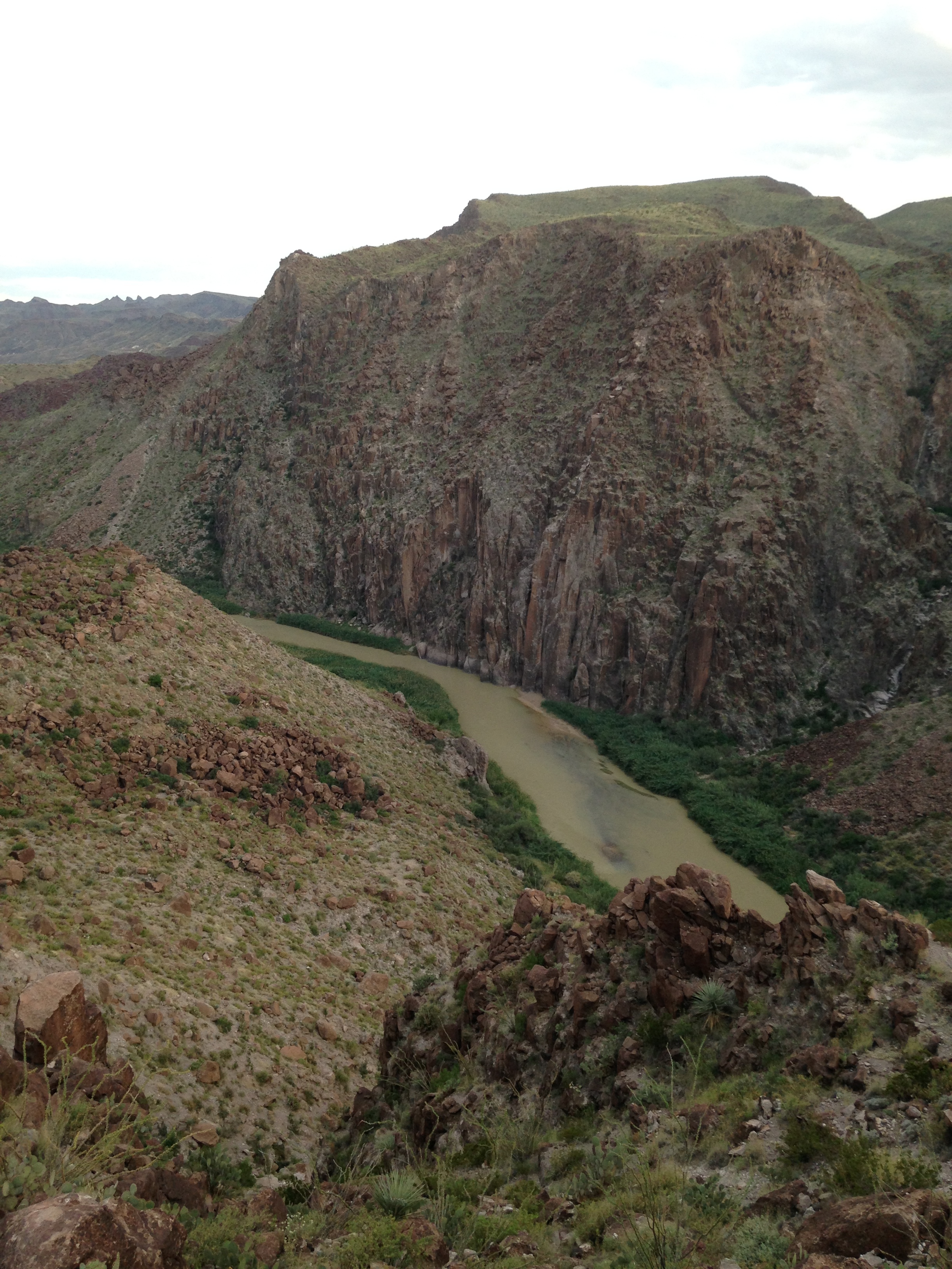
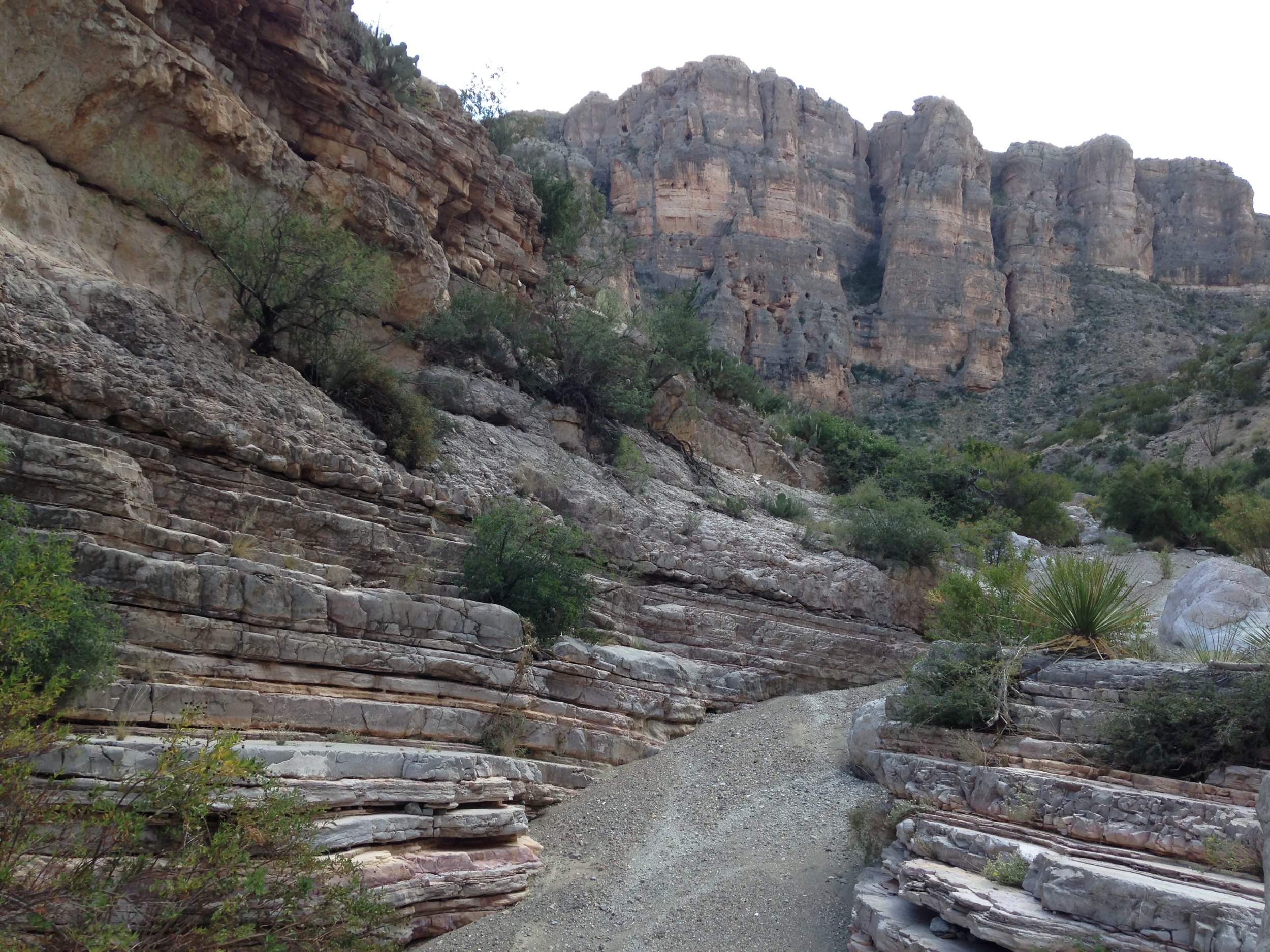
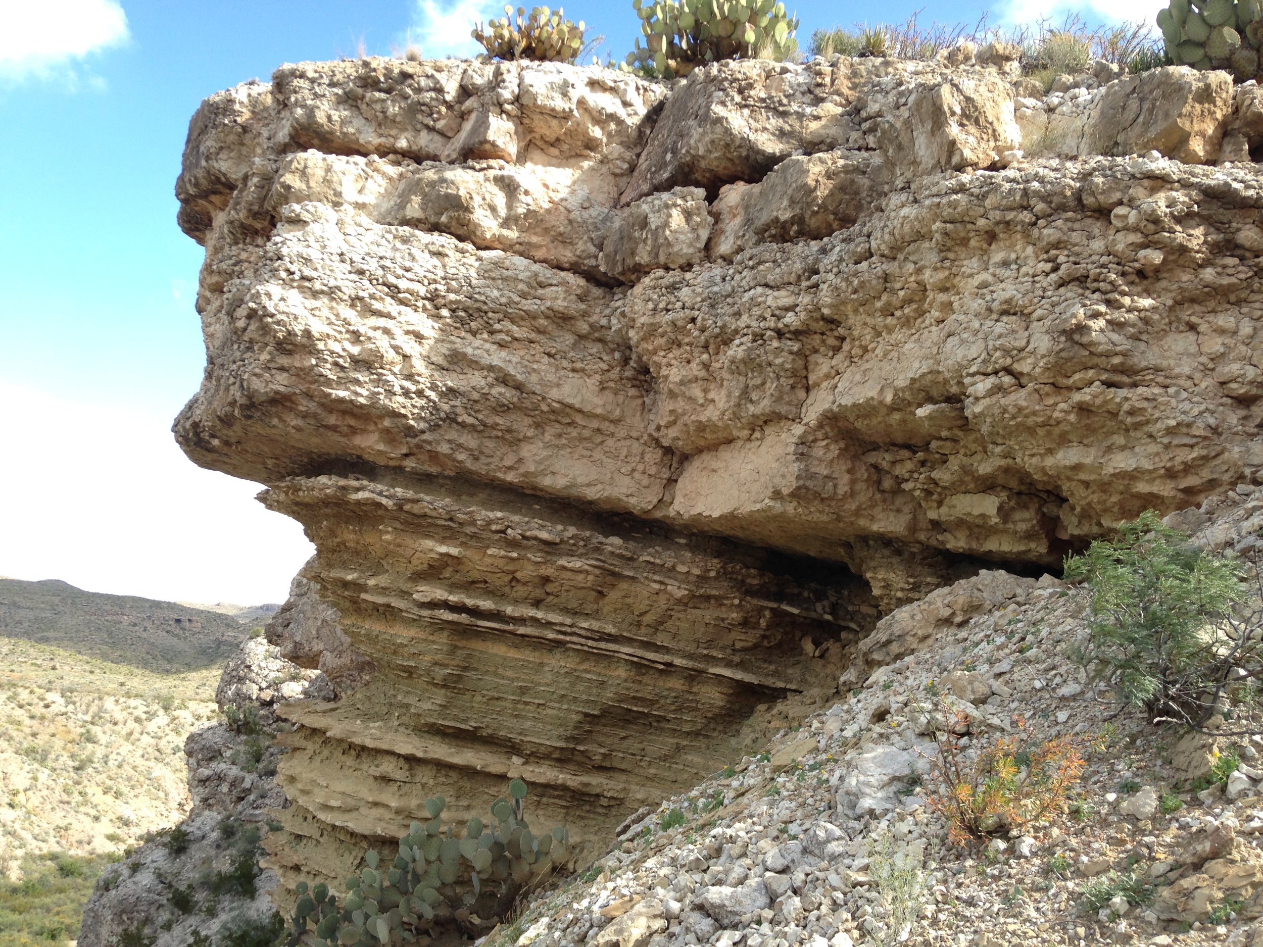
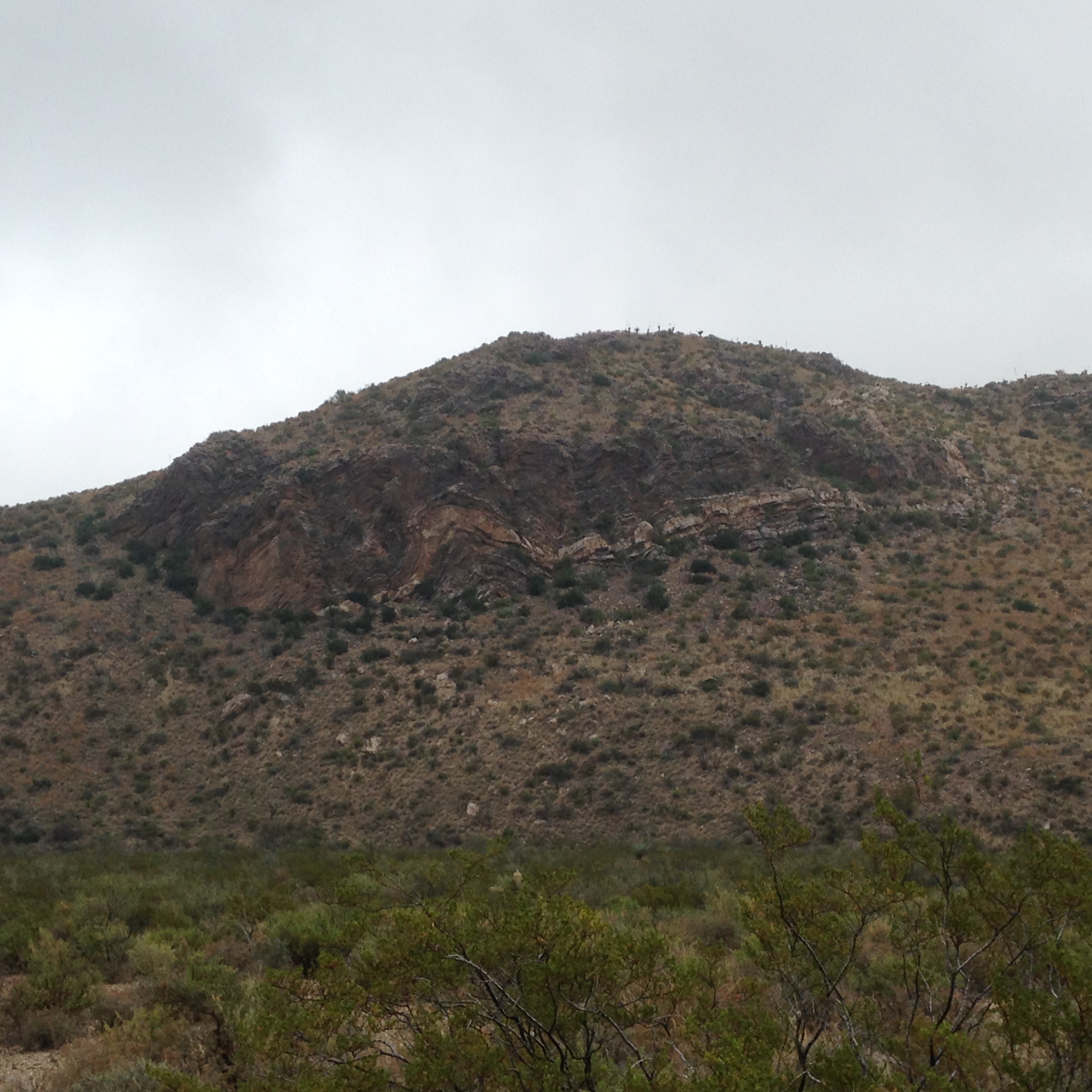
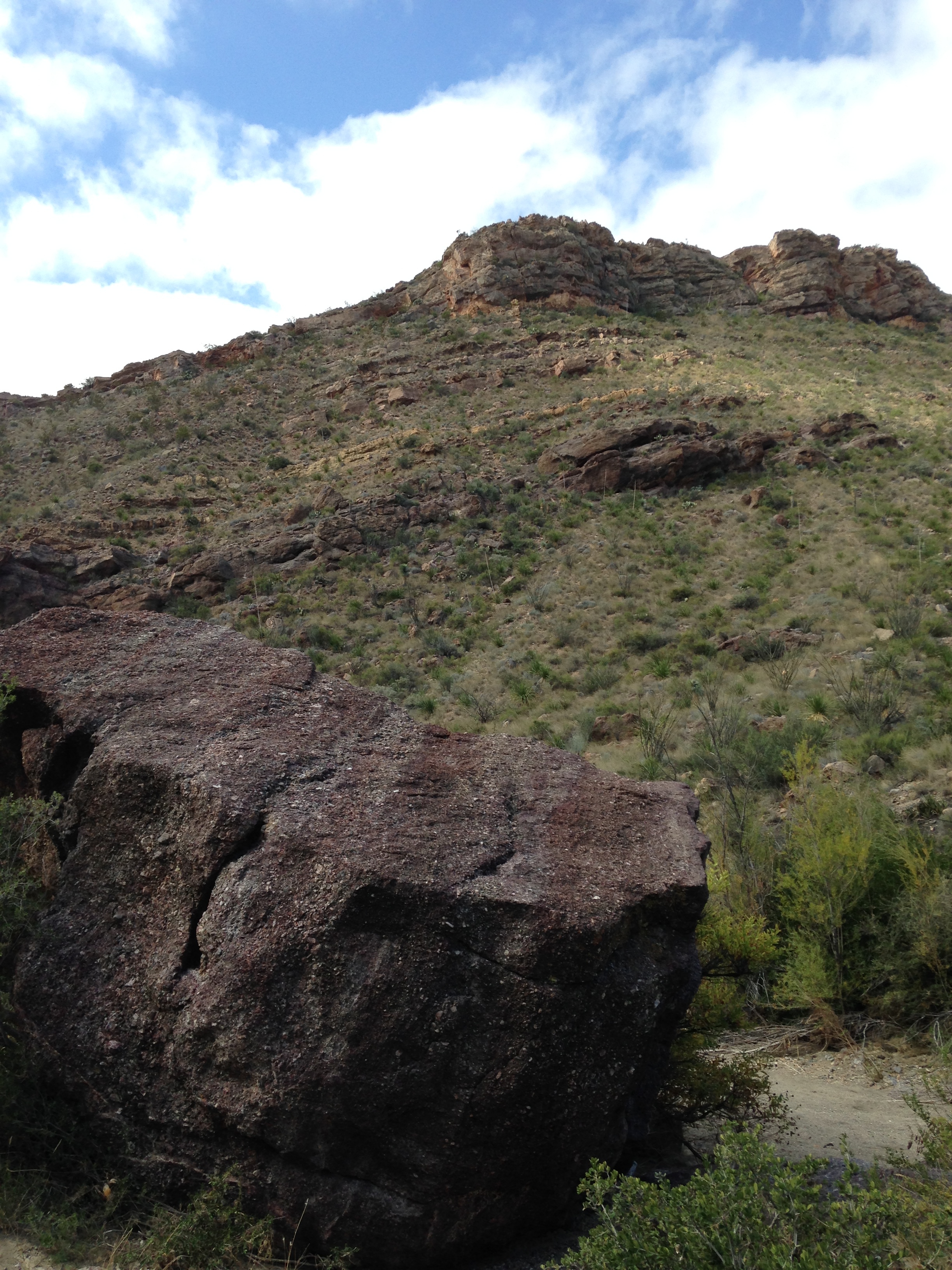
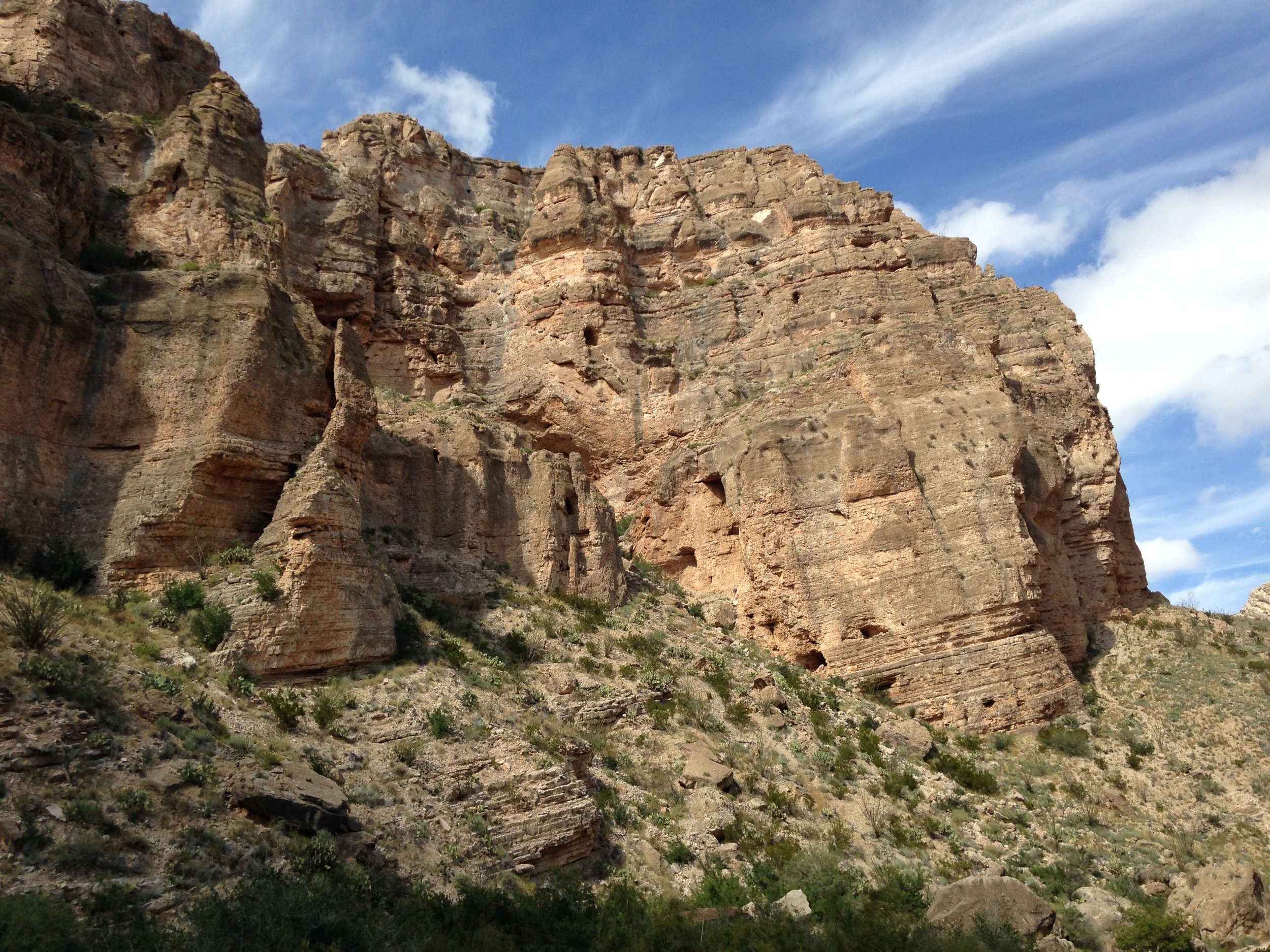
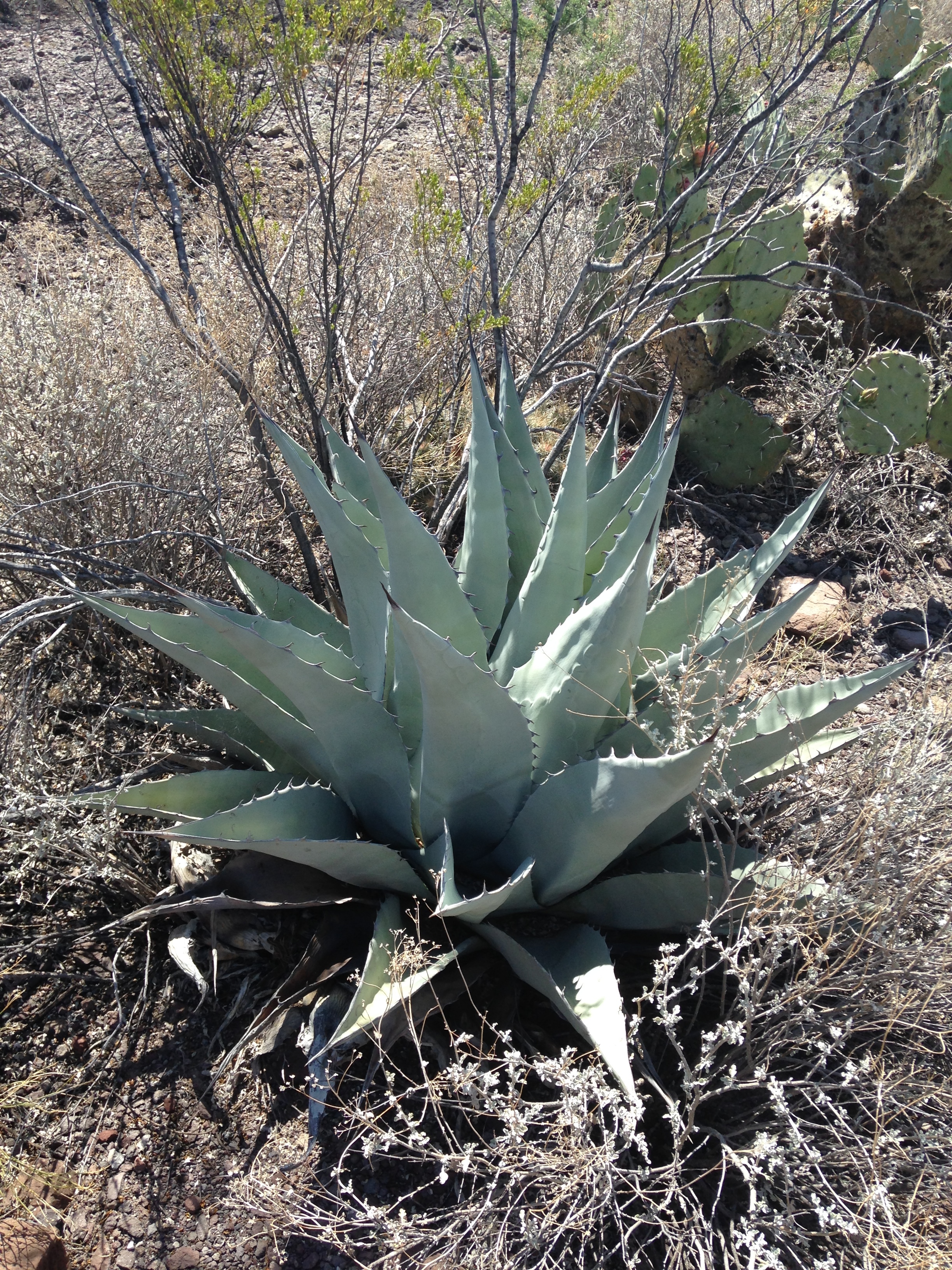
Spectacular outcrops of Upper Cambrian microbial reefs and related facies in Mason County, Texas, offer unique opportunities to assess varying scales of spatial facies variation and potentially serve as important subsurface reservoir analogs. The main microbial interval, covering 25 km2 in the study areawhere bioherms and biostromes beautifully crop out in cliffs and pavements (bedding plane exposures)along several river and creek valleys, has yielded important reservoir insight along several key themes.

Exploration-scale variability – These deposits formed on a broad ramp-like shelf during an overall transgression. Cliff exposures show the stratigraphic framework and positioning of the microbial interval above a prominent flooding surface, as well as the largest-scale clustering of reefs. Multiple 8-15 m-thick and 65-90 m-wide microbial reefs are linked laterally by a series of oolitic and skeletal grainstone beds alternating with thinner siltstones.

Development-scale variability – Closer examination of the cliffs reveals three growth phases to the reefs, evolving from an initial ‘colonization’ phase, into a ‘vertical aggradation and lateral expansion’ phase, and ultimately into a ‘capping’ phase and reef demise. Internal facies and relations between reefs and adjacent sediments vary with the growth phases. Pavement outcrops show field-scale and interwell-scale clustering of reefs along with a spectrum of reef attributes.

Reservoir modeling input – One pavement unique for its size (600m x 200m) and quality of exposure offers key scaling insight into reef heterogeneity across a range of scales (large from 15 to 40 m in length, medium 1.5 to 15 m, and smallest 10 to 80 cm) and quantification of reef attributes such as size, shape, orientation, spacing, and rind vs core proportions. As the size of a microbial head/reef increases the shapes becomes more elongated in one direction, growing parallel to a dominant environmental condition (likely currents).

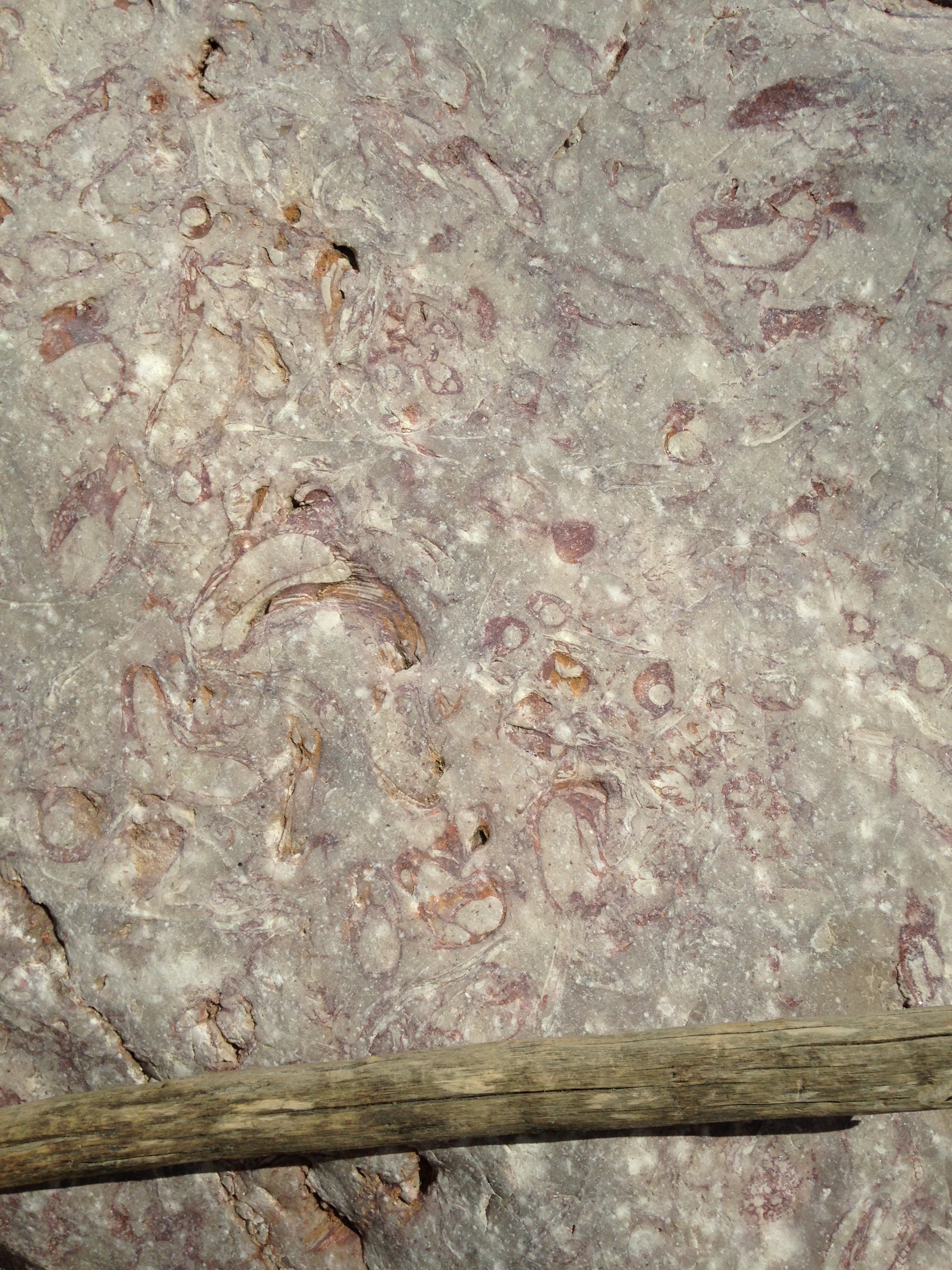
Facies definition – Extensive coring of the outcrops (n=230) shows details of rock textures for various depositional environments, including stromatolitic reef core, thrombolytic reef rind (outer margin), and inter-reef deposits. In general, thrombolitic fabrics retain minimal porosity and permeability and have been mostly unaffected by diagenesis compared to the relatively high porosity and permeability of stromatolitic fabrics, which have been heavily dolomitized.


bio

I am a professor in the Department of Earth Science and currently the Track Director of the Science Master's Program - Subsurface Geoscience. My research has focused on studying the morphology of and the sediments accumulating on slopes and basin floors surrounding coral reefs and carbonate platforms. Over the past 30 years, I have conducted research programs mostly in the Bahamas, offshore Jamaica, along the Belize margin, in the western Gulf of Mexico, in the Maldives (Indian Ocean), along the Australian Great Barrier Reef and in the Gulf of Papua (Papua New Guinea). The main focuses of my research include the regional and global evolution of coral reefs through time, the paleo-oceanographic/climatic and sea level records archived in the sediments deposited around reefs and carbonate platforms. In contrast with my 30 years plus research as a marine geologist, I am currently conducting research on Upper Cambrian Microbial Reefs in Mason County, Central Texas funded by an Industry Consortium in collaboration with my colleague Prof. Dan Lehrmann at Trinity University in San Antonio (Texas).


My work has been funded by the National Science Foundation, the American Chemical Society, and grants from oil and gas companies.


Before becoming an assistant professor at Rice in January 1987, I was a postdoctoral research scientist at the University of South Carolina from 1985 to 1986. I received my Master’s degree equivalent from the University of Neuchâtel (Switzerland) in 1978 and earned his Ph.D. from the Rosenstiel School of Marine and Atmospheric Sciences at the University of Miami (Florida) in 1984.


View Event →
Oct
4
to Oct 6

AGS Sponsors: 6th annual HydroGeo Workshop

The Texas Hydro-Geo Workshop is centered on the collection, processing, analysis and evaluation of hydrologic and geologic field data. It serves as an excellent introduction for aspiring geology, hydrology, and environmental science students, as well as a refresher for seasoned professionals.

The Workshop was created to bring students and professionals together in a field setting for a hands-on learning experience. This is a special opportunity to work with leading researchers and practitioners from across the state and nation. Participants have the opportunity to explore many different techniques for collecting data from soil, rock, and water media. This includes drilling rigs, surface and borehole geophysics, stream gauging, water quality instruments and more.

Participants can select from the various modules depending upon availability. Please note that participation may be limited in some modules for safety reasons, to maintain a high participant/coordinator ratio, or for resource protection.

The Workshop will take place at and around Cave Without a Name near Boerne, Texas (Kendall County) Most activities will be centered at the campsite and pavilion.

Click here for more information

View Event →
Aug
26
6:30 PM18:30

AGS Annual Ethics Meeting (August 26): Federal Judge Lynn Hughes

“Meditation on Power”

by US District Judge Lynn Hughes

AGS will hold it’s annual ethics talk with US District Judge Lynn Hughes as its speaker. Since approximately 2008, Hughes has been a lecturer focusing on ethical issues for the American Association of Petroleum Geologists .

We will also have an introduction and comments prior to the lecture from the TBPG Executive Director, Rene Truan.

https://www.txs.uscourts.gov/content/lynn-n-hughes-united-states-district-judge

https://www.txs.uscourts.gov/content/lynn-n-hughes-united-states-district-judge

Biography

Lynn Hughes is a United States District Judge in Houston. Before his appointment in 1985, he served Texas as a trial judge for six years – That is 40 years. In his spare time, Judge Hughes taught law at South Texas College of Law for 30 years – where he is now on the board of visitors – and he did two stints at the University of Texas Law School. He served for 12 years on the advisory board of the Law & Economics Center of George Mason’s Law School. He has been the lecturer for ethics for the Amer-ican Association of Petroleum Geologists.

He received his bachelor of arts in anthropology from the University of Alabama, his doctor of juris- prudence from the University of Texas, and his master of laws from the University of Virginia. Early in his law practice, he got something of a business education by running a mining-equipment venture in Texas and British Columbia.

He has advised the European Community and several East European countries on constitutional law and privatization. He is a director and former chairman of the World Affairs Council of Houston and a member of the Council on Foreign Relations.


View Event →
Jun
3
6:00 PM18:00

AGS Meeting (June 3): Refining the Vapor Intrusion Conceptual Model: From Soils to Sewers

Refining the Vapor Intrusion Conceptual Model:  From Soils to Sewers

 Lila Beckley

Abstract

 Vapor intrusion is the migration of volatile organic compounds from contaminated groundwater or soil into buildings.  Because it is a mechanism that could potentially expose people to harmful chemicals, vapor intrusion is scrutinized in a variety of contexts including real estate transactions and regulatory oversight of contaminated site cleanups.  The conventional vapor intrusion conceptual model that has been recognized since the 1990s involves contaminant transport up through the vadose zone into buildings.  In recent years, however, there has been a growing recognition that sewers and utility tunnels can act as preferential pathways for vapor intrusion.  In this talk, I will discuss the evolving vapor intrusion conceptual model including conventional mechanisms, the influence of shallow soils on vapor migration in the subsurface, and the role of sewers/utility tunnels as preferential pathways.  Presenting data from several of GSI’s ESTCP VI research projects, I will also provide recommendations for evaluating sites to determine whether vapor intrusion is a concern. 


lila beckley.png

 Bio

 Lila Beckley is a senior geologist with GSI Environmental Inc., in Austin, Texas, with more than 24 years of experience in the environmental field.  She received M.A. and B.S. degrees in Geological Sciences from the University of Texas at Austin.  Her current focus areas include regulatory and litigation support, and vapor intrusion.  In the area of vapor intrusion, she has developed investigation protocols through DoD-funded research; conducted assessments of residential, industrial, and military sites around the U.S.; and developed guidance and training.  Prior to joining GSI, Lila worked in enforcement and remediation programs at the Texas Commission on Environmental Quality (TCEQ), in various roles ranging from project to program management.

View Event →
May
6
6:00 PM18:00

AGS Meeting (May 6): Extraterrestrial Sed/Strat: Reconstructing the Evolution of a Delta Deposit on Mars

Title: Extraterrestrial Sed/Strat: Reconstructing the Evolution of a Delta Deposit on Mars

 By: Tim Goudge

Summary:

Decades of planetary exploration have revealed widespread evidence for ancient aqueous activity on the surface of Mars, including hydrous alteration minerals, deeply incised valleys, paleolake basins, and fluvio-lacustrine sedimentary deposits. In this talk I will provide an overview of the various lines of evidence for water on early Mars, and discuss outstanding questions on the details of the ancient martian surface environment. I will also present recent work aimed at reconstructing the evolution of a delta deposit within Jezero crater, the landing site for the next NASA rover - the Mars 2020 mission. The Jezero delta is also a representative example of ancient fluvial stratigraphy on Mars, and so these results can help to improve our understanding of the early martian climate and hydrologic cycle.


Goudge_Photo_3.jpg

Tim Goudge

Bio:

Tim Goudge is an Assistant Professor in the Department of Geological Sciences within the Jackson School of Geosciences at the University of Texas at Austin. Dr. Goudge’s scientific interests focus on the role of surface processes in controlling the evolution of planetary landscapes. His research uses remote sensing data to study the signatures of these processes recorded in the topography, mineralogy, and sedimentary rock record of Mars, Earth, and other planetary bodies. Dr. Goudge received a BSc in geological engineering from Queen’s University, and a ScM and PhD from Brown University.

View Event →
Apr
1
6:00 PM18:00

AGS Meeting (April 1): AGS Research Symposium

AGS Research Symposium

This event will include poster presentations from the top student posters from the Jackson school and from the Austin Regional Science fair, and will include a cash prize for the winners in each category.

  • $100 for Best PhD Poster

  • $100 for Best Masters Poster

  • $100 for Best Undergraduate Poster

  • $100 for Best High School Poster

Location:

This will likely take place again in the BEG multi purpose room.

View Event →
Mar
4
6:00 PM18:00

AGS Meeting (March 4): Investigating the ecological and biogeochemical consequences of water storage in weathered bedrock

Dr. Daniella M Rempe

Assistant Professor, Department of Geological Sciences, Jackson School of Geosciences

Abstract

Many mountainous landscapes are mantled with thin soils that overlie meters to tens of meters of weathered bedrock. This transition zone between soil and bedrock often controls how infiltrating water is partitioned between evapotranspiration and runoff, as well as the rate and pattern of chemical denudation in a landscape. Despite this region’s significance to hydrologic and geomorphic processes, it is largely invisible to observation and the geochemical reactions and hydraulic properties that govern its structural evolution over time are poorly constrained. In this talk, I will present results from an intensive effort to directly quantify the complex fluid and solute pathways in the weathered bedrock region at the Eel River Critical Zone Observatory (ERCZO). We have instrumented an 18 m thick variably saturated argillite weathering profile in the uplifting Northern California Coast Ranges with a series of flexible sensors and samplers that span the continuum from soil to fresh bedrock. In the seasonally dry setting, we observe significant hydrologic dynamics within the weathered bedrock region. Wet-season rainfall passes through unsaturated fractured bedrock before reaching the groundwater table and running off to the adjacent stream. The water that is seasonally stored in the weathered bedrock (rock moisture) is used by plants for transpiration. Using our sampling system, we have collected nearly two years of bi-weekly major and trace ion chemistry from samplers distributed within the weathered bedrock region that separately collect freely draining and tension-held water. We compare water chemistry to in-situ water content and gas phase O2 and CO2 , as well as rock characterization data such as bulk density and elemental composition, to identify controls on the observed solute concentrations. Our preliminary results reveal that both the freely-draining and tension-held waters are seasonally geochemically dynamic, while these same dynamics are dampened or absent in groundwater and streamflow. The tension-held samples show consistently higher concentrations relative to freely draining fluid, suggesting that the dual-domain nature (i.e. flow through matrix and fracture components) of the weathered bedrock system significantly impacts solute generation and weathering of bedrock. We compare our field observations to preliminary 1D reactive transport simulations to explore the role of dual-domain transport on weathering reactions. Our results highlight the coupled nature of geochemical and hydrologic processes in weathered bedrock and the importance of studying this region in Earth’s Critical Zone.

daniella_rempe_2976_thumb.jpg

Bio:

Daniella Rempe is a hydrologist and geomorphologist interested in understanding how the evolution of the near-surface environment drives hydrologic and ecologic processes. She uses a diverse set of hydrological and geophysical field techniques to probe the interior of hillslopes to understand how surface and subsurface processes influence water resources to vegetation, rivers, and the atmosphere. Learn more about Daniella's research interests on the webpage “Rempe Research Group”.

View Event →
Feb
25
to Feb 27

AGS Spring 2019 Field Trip: Geology at the Crossroads - Big Bend Ranch State Park, West Texas

  • Big Bend Ranch State Park (map)
  • Google Calendar ICS

Geology at the Crossroads - Big Bend Ranch State Park Presidio and Brewster Counties, West Texas

TRIP DETAILS - COST, PMT DUE DATE pg2_Page_1.jpg
TRIP DETAILS - COST, PMT DUE DATE pg2_Page_2.jpg

Pre- and Post-trip Lodging information:

February 24th (night before departure) and again on February 27th (return to Alpine) participants will need to arrange their own accommodation.

The Quarter Circle 7 Hotel has agreed to block 15 double occupancy (queen beds) rooms. The reduced rate for participants of the AGS Field Trip is $120.60 before taxes, $60.30 per person. If not doubling up please do not request the blocked rooms. Reservations can be made by calling the Quarter Circle 7 Hotel directly at (432) 837 - 1100 and requesting the Austin Geological Society rate. The Hotel Manager's name is Ms. Rebecca Pape.

This location will be the starting and ending points for the trip and all field trip participants will need to assemble there at 7:30 on Monday, February 25th, for prompt departure to Big Bend Ranch State Park. The hotel is located on the West side of town. I have also arranged for monitored parking for all personal vehicles to be left there during the trip. (Hopefully people will be carpooling where possible.) No personnel vehicles will accompany the trip.


View Event →
Feb
4
6:00 PM18:00

AGS Meeting (February 4): Neogene Evolution of Central Texas Landscape after Balcones Faulting 

Neogene Evolution of Central Texas Landscape after Balcones Faulting

Dr. Peter R. Rose

click here for handout

The Edwards Plateau and the Balcones Fault Zone (BFZ) dominate the geology and physiography of Central Texas. The Edwards Plateau was formed during Early Miocene time by uplift of the area west and north of the arcuate BFZ. The Albian Edwards Group was a continuous sheet of resistant shallow-shelf carbonate strata that covered all of central Texas: the Edwards Plateau, BFZ, and subsurface of the Central Texas Platform. At the time of first Balcones faulting, the Edwards was widely exposed west and north of the BFZ. Regional headward erosion and dissolution following Balcones faulting progressively stripped away Edwards strata, leaving steep, ragged bluffs that delineated the boundaries of the Edwards Plateau. Just as geological maps outline the Edwards Plateau today, a reconstruction of past Edwards Limestone outcrop locations records the stages of westward and northern erosional retreat through Miocene, Pliocene, Pleistocene and Holocene times.

This integrated geologic/geomorphic/hydrologic account is based upon three different categories of diagrams, prepared specifically for this paper:

  1. A map showing the 26 drainage basins of central Texas;

  2. Stream profiles of 12 rivers sourced from the Edwards Plateau Aquifer, in context with adjacent geologic boundaries of top (tKed) and base (bKed) of the Edwards Group, and base (bK) of Cretaceous formations within the map area;

  3. Seven paleogeographic maps of the Edwards Plateau/BFZ area from onset of Balcones faulting (21 mya) to the present time, showing the location of the Edwards Plateau and the courses of all main streams, in 3.5 my stages.

The sequential evolution of the Central Texas landscape is integrated with independent evidence from five related geological processes and events to generate a holistic account of Edwards Plateau and BFZ history since early Miocene time:

  1. Incised meanders of Edwards Plateau rivers and streams, inboard and peripheral to the BFZ, were probably inherited from early Paleocene conditions, then greatly amplified by Balcones-related uplift.

  2. High porosity and permeability of Edwards strata in the central sector of the BFZ and Edwards Underground Aquifer is related to a) a longer period of increased stream gradients and stream piracy in that sector; b) a wider BFZ with greatest vertical displacement; and c) the presence of a major discharge point at the lowest elevation in the trend, at San Marcos Springs.

  3. Between 14 and 10.5 mya, the Colorado River formed its Great Bend, when it shifted its course about 35 miles north and east, after eroding through Cretaceous strata, downward onto hard, northeast-dipping Paleozoic beds. This shift also generated the marked asymmetry of the Colorado drainage basin, with short tributaries on the east, and long straight tributaries on the west.

  4. Multiple levels of horizontal cave development (youngest downward) in the western Edwards Plateau suggest that the thickness of the Edwards Plateau aquifer was greatest immediately following Balcones faulting, and declined afterward in stages as erosion reduced the area of surface recharge, and increased outflows.

  5. The post-Balcones Medina Arch induced concave-upward stream profiles in streams originating around its apex: Pedernales, Blanco, Guadalupe, Medina, Frio, and East Nueces Rivers.

PeteRose.jpg

Biography

Dr. Pete Rose (Ph. D., Geology, University of Texas, Austin) has been a professional geologist for 59 years, specializing in Carbonate Stratigraphy, Petroleum Geology, E&P Risk Analysis, and Mineral Economics. Before going on his own in 1980 as an independent prospector and consultant, he worked for Shell Oil Company, the United States Geological Survey, and Energy Reserves Group, Inc, a small-cap Independent.

After 10 years as an internationally-recognized authority on economic risking of exploration drilling ventures, he founded Rose & Associates, LLP, in 1998.  His 2001 book, Risk Analysis and Management of Petroleum Exploration Ventures, now in its 7th printing, is considered by many as the “Bible” on that topic, and has been translated into Chinese, Japanese, and Russian.  Pete retired in 2005; Rose and Associates LLP continues as the global standard among consulting companies in that field, providing instruction, software and consulting services on an international scale.

Pete wrote the definitive geological monograph on the Edwards Limestone of Texas (Rose, 1972), and has continued related investigations to the present time -- this will be  his 10th published paper on various aspects of the Edwards Plateau area.  He has authored or co-authored more than 80 published articles on an extremely wide variety of geological topics. He was a Fellow of the Geological Society of America, the American Association for the Advancement of Science, and Geological Society of London.

In 2005 he was the 89th President of the American Association of Petroleum Geologists, In 2006-07 he was deeply involved in successful efforts to encourage the U. S. Securities and Exchange Commission to modernize its rules governing estimation and disclosure of oil and gas reserves, thus facilitating the investment component of the “shale revolution” in the U. S. Pete ws President of the Austin geological Society in 2012/13.

In 2013, the Geological Society of London awarded Peter R. Rose its prestigious Petroleum Group Medal for lifetime contributions to Petroleum Geology, the first American to be so recognized, and in 2014 the American Association of Petroleum Geologists honored him with its Halbouty Outstanding Leadership Award.

View Event →